What are the types of government systems in other countries?
Step 1: Go to the ArcGIS Online map, Governments Around the World, and explore the map.
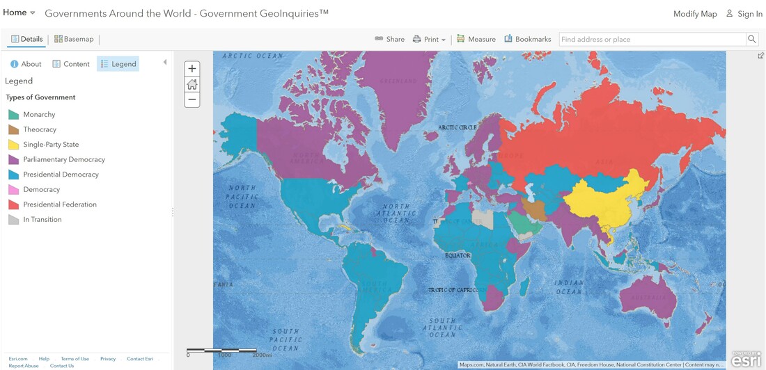
Step 2: With the Details button underlined, click the button, Show Map Legend.
- What colors represent which governments?
- Which color is the United States, and what form of government does this color mean the United States has?
https://www.youtube.com/watch?v=x0XbYvppUQw
What is the distribution of governments around the world?
- What is the most common form of government?
- What do the gray-colored countries have in common? (Hint: Click the In-Transition countries to open a pop-up for more information.
- Most countries around the world have a form of democracy. What is the difference between parliamentary and presidential democracy? (T/F)
https://www.youtube.com/watch?v=VOAYUwQTTdQ
When did countries around the world gain their independence?
Step 3: With the Details button underlined, click the button, Show Contents of Map.
Step 4: Turn off the layer, Types of Government.
Step 5: Turn on the layer, Independence by Year.
Step 6: Press the button, Show Map Legend to see the categories of years.
- What international organization was first formed in 1920?
What has occurred since the 1920s?
Step 7: Look for the coordinating color on the choropleth map to identify 1940-1960.
- Following World War II, countries were divided, and new countries were formed. (T/F)
Step 8: Look for the color that represents 1960-1979 and 1980-1999.
Step 9: Click Bookmarks and choose the Eastern Hemisphere bookmark.
- Following the end of colonialism, most countries under colonial rule lost their independence. (T/F)\What trends might help explain why some areas gained independence later than others?
- Which new country was created since 2000?
How have world events affected the distribution of government types globally?
Step 11: Toggle the layer on and off, so that you can see both layers.
- How did the world change after the end of the Cold War? (Hint: Pay attention to western Asia after the collapse of the USSR.)
- One spatial pattern that is observable on the map is that countries that gained their independence from the U.S.S.R chose a democratic government model. (T/F)
https://www.youtube.com/watch?v=xrSBVI1Vshc
